-
YourGovernment
-
Column 1
- Board of Supervisors
- Boards/Commissions
- Agendas/Minutes
- County Code
- Freedom of Information Act (FOIA)
- Local Elected Officials
- Policies and Forms
- Public Hearings
- 2020 Residents Survey
Column 2
- Departments
- Administration
- Animal Control
- Children's Services (CSA)
- Clerk of the Circuit Court
- Commissioner of the
Revenue - Commonwealth's Attorney
- Community Development
- Building Inspections
- Planning & Zoning
- Cooperative Extension
- County Attorney
- Economic Development
Column 3
-
-
CountyServices
-
Column 1
- About
- 2016 Report to Citizens
- Directions to Palmyra
- Fluvanna Quick Facts
- Fluvanna History
- Public Facilities Map
- Privacy Policy
- County Calendar
- Community Resources
Guide - EMS Billing
- Solid Waste & Recycling
- Business Directory
Column 2
- Human Services
- Fair Housing
- Blue Ridge Health District
- Rx Card Program
- Senior Resources
- Social Services
- Veterans Services
- Library
- Public Safety
- Emergency Services
- Emergency Alert System
- Sheriff's Office
Column 3
-
- Focus onBusiness
-
WelcomeVisitors
-
Column 1
- About
- 2016 Report to Citizens
- Directions to Palmyra
- Fluvanna Quick Facts
- Fluvanna History
- Fluvanna Interactive Map
- Privacy Policy
- County Calendar
- Public Facilities Map
- Community Resources
Guide - Business Directory
- Public Hearings
Column 2
- Community
- Arts & Culture
- Community Events
Calendar - Community Service Award
Nomination Form - Fluvanna Volunteers
- Photo Submission Form
- Senior Resources
- Fluvanna SPCA
- Library
- Public Safety
- Emergency Services
- Emergency Alert System
- Sheriff's Office
Column 3
-
-
I WantTo...
-
Column 1
- Be Informed
- Agendas and Minutes
- County Calendar
- Emergency Alert System
- FAN Mail
- County News
- Contact the County
- My Two Cents
- Staff Directory
- Recognize
- Residents
- Employees
Column 2
- Find/View
- Budget
- County Code
- County Facilities
- County Surplus For Sale
- Court Information
- Documents & Reports
- Permits & Forms
- FAQs
- Job Openings
- Parks & Rec Registration
- Reserve Commercial Kitchen
Column 3
-
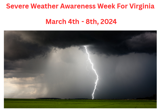
Severe Weather Awareness Week March 4th - 8th, 2024
VDEM is partnering with the National Weather Service to promote Severe Weather Awareness Week. The week is designed to refresh, remind, and educate everyone about the seasonal threats from severe weather and how to avoid them. It’s also a great time to make and practice your emergency plan!
The week is usually planned for March and includes a statewide tornado drill. Virginia’s Severe Weather Awareness Week will be from March 4-8, 2024, with the Statewide Tornado Drill taking place on Thursday, March 7, 2024, at 9:45 a.m. Every school, business, workplace, and family across the commonwealth is strongly encouraged to participate in the statewide tornado drill. The drill will be broadcast on NOAA Weather Radio and the Emergency Alert System via the Required Monthly Test (RMT). There WILL NOT be an actual Tornado Warning issued and the notification WILL NOT be sent to cellular phones.
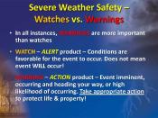
Monday, March 4, 2024 - Watch vs Warning
What is the difference between weather Watches and Warnings?
- A WATCH (Severe Thunderstorm or Tornado) is issued when severe thunderstorms and/or tornadoes are possible in and near the watch area. it does not mean that they will occur, it only means they are possible.
- Severe thunderstorms are defined as follows:
- Winds of 58 mph or higher and/or
- Hail 1inch in diameter or larger
- A WARNING is issued by our local National Weather Service office when a Severe Thunderstorm or Tornado is imminent or occurring. Seek safe shelter and observe safety protocols.
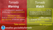
Tuesday, March 5, 2024 - Tornadoes
- A Tornado WATCH is issued by the NOAA Storm Prediction Center meteorologists who watch the weather 24/7 across the entire U.S. for weather conditions that are favorable for tornadoes and severe weather. A watch can cover parts of a state or several states. Watch and prepare for severe weather and stay tuned to NOAA Weather Radio to know when warnings are issued.
- A Tornado WARNING is issued by your local NOAA National Weather Service Forecast Office meteorologists who watch the weather 24/7 over a designated area. This means a tornado has been reported by spotters or indicated by radar and there is a serious threat to life and property to those in the path of the tornado. A tornado warning indicates that you should ACT NOW to find safe shelter! A warning can cover parts of counties or several counties in the path of danger.
Watch this Youtube video for a great explanation!
Wednesday, March 6, 2024 - Severe Thunder Storms: Hail, Lightning, and Wind
- A thunderstorm is classified as “severe” when it contains one or more of the following: hail one inch or greater, winds gusting in excess of 50 knots (57.5 mph), or a tornado
- Thunderstorms are most likely in the spring and summer months and during the afternoon and evening hours, but they can occur year-round and at all hours.
- Along the Gulf Coast and across the southeastern and western states, most thunderstorms occur during the afternoon. Thunderstorms frequently occur in the late afternoon and at night in the Plains states.

Thursday, March 7, 2024 - Flash Flooding
- Flooding is an overflowing of water onto land that is normally dry. Floods can happen during heavy rains, when ocean waves come on shore, when snow melts quickly, or when dams or levees break. Damaging flooding may happen with only a few inches of water, or it may cover a house to the rooftop. Floods can occur within minutes or over a long period, and may last days, weeks, or longer. Floods are the most common and widespread of all weather-related natural disasters.

Friday, March 8, 2024 - Outdoor Weather Safety
With spring just around the corner, outdoor activities, like sporting events, camping, hiking and boating, will be once again becoming more prevalent. It is is important that not only are people prepared at home for severe weather, but also for when they are outside enjoying all fun activities available in the Commonwealth of Virginia. Here are some tips to help with outdoor weather safety and preparedness:
- Know Before You Go! Before heading outdoors, check the latest forecast from https://www.weather.gov/akq/, or from a trusted weather source. If severe weather is expected, stay home, or go before the weather is expected to deteriorate.
- Monitor the Weather. Have a NOAA Weather Radio, and/or apps that have radar and lightning data. Make sure you have a way to receive weather warnings.
- Stop all Activities when you hear thunder or when weather conditions look threatening. The first lightning strike can come out of a clear blue sky many miles ahead of an approaching thunderstorm cloud.
- Know your area. In hilly terrain, flash floods can strike with little or no advance warning -- Distant rain may be channeled into gullies and ravines, turning a quiet stream into a rampaging torrent in minutes -- Never camp on low ground next to streams since a flash flood can catch you while you're asleep
- Turn Around Don't Drown. If you come upon flood waters, stop, turn around, and go another way. Climb to higher ground
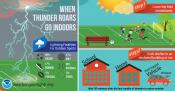
- When Thunder Roars Go Indoors. There is no 100% safe shelter outside. The only place of safety from lightning is inside a vehicle or a substantial, enclosed structure.. Do not take shelter in small sheds, under isolated trees, or in convertible automobiles. Stay away from tall objects such as towers, fences, telephone poles, and power lines.
For additional safety tips please visit our Outdoor Weather Safety and Preparedness Page.